Advanced sonar technology has allowed ships to create highly detailed topographic maps, it would take 125-200 ship-years to survey the deep oceans alone, costing billions of dollars. Gravity models are powerful tools for charting large areas of the ocean where tectonic structures and deep ocean basins remain unmapped by ships or hidden under thick sediment.
The new marine gravity model announced by a team of international scientists’ shows unprecedented resolution of the seafloor uncovering several new tectonic features. It is an exciting time for ocean exploration as each new year reveals more of the uncharted oceans, catalyzing new developments in plate tectonics, navigation, petroleum exploration and earthquake forecasting.
Ship-based surveys remain a vital and valuable tool for decades, the topographic mapping is limited by the number of ship crossings. As such, only around 11 percent of the seafloor has been mapped at high resolution and 17 percent at a lower resolution to date. In 1978, NASA’s Seasat altimeter was the first to demonstrate the ability to gather seafloor bathymetry from space.
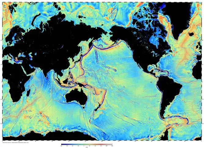
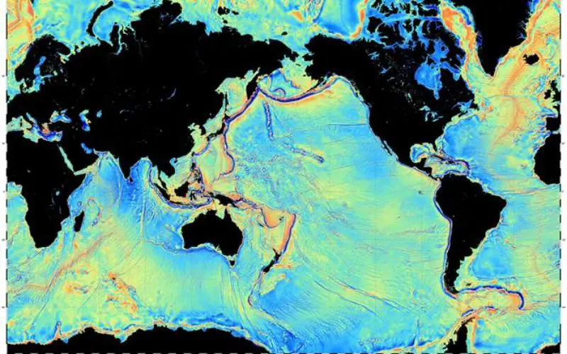
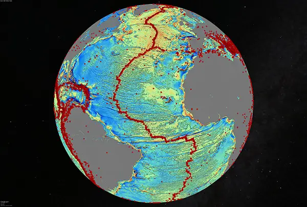
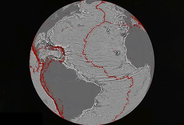
Global map of the variations in the pull of gravity derived from satellite radar altimetry. Credit: Scripps Institution of Oceanography
For decades, David Sandwell from the Scripps Institution of Oceanography and Walter Smith from the National Oceanic and Atmospheric Administration (NOAA) have been using Earth’s gravity field data from the civilian and military satellite operators. By combining new radar altimeter measurements from satellites such as the European Space Agency’s (ESA) CryoSat-2 and NASA CNES Jason-1 with existing data, a global marine gravity model was constructed that is two times more accurate than previous models. The team of scientists included R. Dietmar Müller from the University of Sydney, EmmanuelGarcia of NOAA and Richard Francis from ESA. The data they collected regarding gravity measurements and sea surface heights have formed unprecedented detailed maps of beneath the oceans’ surfaces.
Global maps constructed using satellite-derived gravity data will never replace the ships. The resolution of this new method is limited by the ocean depth because the potential field which gets smooth as you go from the bottom of the ocean to the surface. Whereas, the standard ship-based multibeam echo-sounders resolves features on the seafloor in high-resolution about 100 meters across. The problem is in our lifetime we will probably never see the complete mapping of the seafloor by ships. Which makes the satellite data vital to filling in the gaps.
The main challenges scientists face in developing these gravity field models is improving the resolution from the satellite altimetry data. Sea surface topography is a noisy measurement as the waves roughen the ocean’s surface making the range measurement less precise.
One the real uses of the gravity field for seafloor mapping is identifying features that are unmapped, but also big in size such as large sea mounts and other structures. This allows researchers and commercial operators to target ship surveys to complete detailed mapping.
The project is still evolving and the interpretation of the results is yet to be completed. As these gravity fields are developed, the fine detailed of tectonic structures formed up to 150 million years ago will need to be interpreted. The objectives of this work will be to unravel the marine tectonics environments and other types of data that needs to be combined into current models.
In January 2016, Google replaced its global seafloor map with an improved version constructed using the latest gravity predictions and the available multibeam sounding data. NASA has a planned swath altimeter mission, SWOT, scheduled for a launch in 2020, that could provide another factor of 5 improvement in global ocean floor bathymetry.
Satellite technology is always evolving, helping scientists follow the movements of Earth’s tectonic plates over time and target areas to study further using sonar scanning. While the increased use of non-invasive methods promise a more environmental friendly future, the continuous discoveries of new seafloor features in deep-sea marine territories marks a huge milestone in understanding our planet.
Read full story at Marine Technology News