Have you ever thought of using LiDAR data through geographic information system to improve field tasks such as Forestry Management, Disaster Prevention, Coastal Change Management, and Contamination Simulation and so on? LiDAR technology, a significant measurement tool for surveyors, supports the measurement technology that can record a wide range of high-precision and diverse information at once, and becomes an important application tool in lots of domains. For example, a forestry-management export can record a large number of data indicating tree height and crown density by using LiDAR data to grasp forest vegetation information and enhance the forecast accuracy of forest states at the same time.
In this way, the forecast exactness of forest fire can be improved for forest patrol to prevent the damage caused by fire. For people who devote attention to disaster prevention, LiDAR data enable them to raise accurate levels of digital terrain model (DTM) and accuracy rate of flood simulation. In urban areas, land is extremely utilized so that a low level of differences of flood elevation may induce extreme impacts. To offer better disaster-relief effects, exact digital terrain models are employed to provide related organizations with high-quality disaster-relief simulations. In addition, LiDAR technologies are also utilized in fields like Contamination Simulation and Urban Planning, as well as Oil and Mineral Explorations, etc.
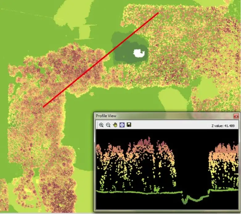
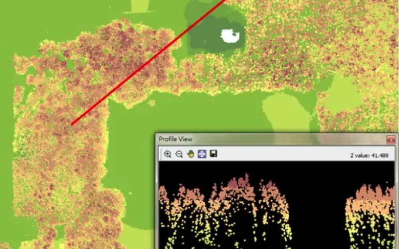
SuperGIS Desktop has been supporting users to display LiDAR data in 2D/3D environments. Soon in the future, SuperGIS Desktop 10 will provide more advanced LiDAR tools for users to display their LiDAR data according to the elevation, RGB and classification values. Besides, via the LiDAR tools within SuperGIS Desktop 10, you can display either surface data, non-surface data, or vegetation data by using the filter tool. LiDAR tools can do more than this; they also allow users to draw LiDAR profile which can be shown in 3D, meeting the demands of terrain distribution of exclusive files. Moreover, the LiDAR data processing function within LiDAR tools enable users to extract information of surface, vegetation, building, water, etc. Meanwhile, point cloud data can be lightened through LiDAR data splitting or merging functions. It is convenient for users to convert their LiDAR data into lighter *.laz, feature, numerical, text data and so forth.
Supergeo Technology has been devoting several years to developing, implementing and promoting diverse GIS products for the world, and making contribution to the society as well. To introduce the way to improve field surveys’ effects via GIS technologies, a global webinar conducted by Supergeo will be hold at 9a.m. on September10. Join the webinar and get to know how to predict species distribution for boosting forestry resources conservation and managements through statistical methods via SuperGIS Desktop!
For more information, visit Supergeo website: http://www.supergeotek.com/productpage_SG3.aspx
Or contact us with e-mail: staff@supergeotek.com
# # #
About Supergeo
Supergeo Technologies Inc. is a leading global provider of GIS software and solutions. Since the establishment, Supergeo has been dedicated to providing state-of-the-art geospatial technologies and comprehensive services for customers around the world. It is our vision to help users utilize geospatial technologies to create a better world.
Supergeo software and applications have been spread over the world to be the backbone of the world’s mapping and spatial analysis. Supergeo is the professional GIS vendor, providing GIS-related users with complete GIS solutions for desktop, mobile, server, and Internet platforms.