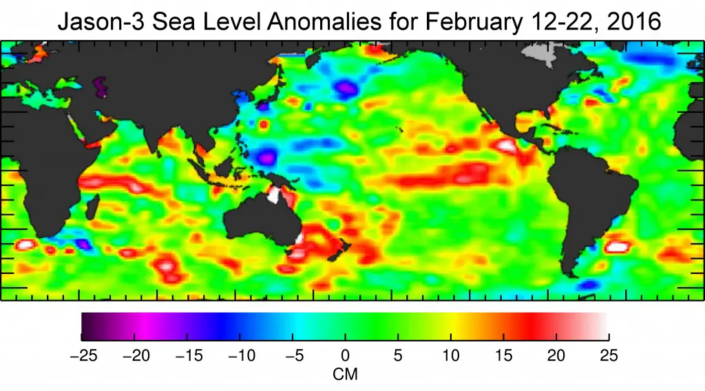
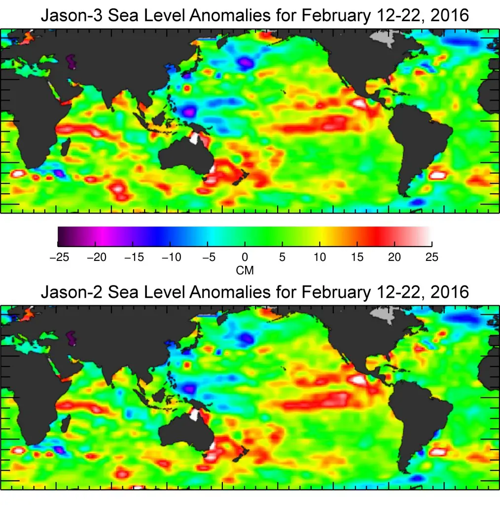
Just over a month after launch, Jason-3, a U.S.-European oceanography satellite mission with NASA participation, has produced its first complete science map of global sea surface height, capturing the current signal of the 2015-16 El Niño.
The map was generated from the first 10 days of data collected once Jason-3 reached its operational orbit of 1,336 kilometers on Feb. 12. It shows the continuing evolution of the ongoing El Niño event that began early last year.
After peaking in January, the high sea levels in the eastern Pacific are now beginning to shrink.
Launched Jan. 17 from California’s Vandenberg Air Force Base, Jason-3 is operated by the National Oceanic and Atmospheric Administration (NOAA) in partnership with NASA, the French Space Agency Centre National d’Etudes Spatiales (CNES) and the European Organisation for the Exploitation of Meteorological Satellites (EUMETSAT).
Its nominal three-year mission will continue nearly a quarter-century record of monitoring changes in global sea level. These measurements of ocean surface topography are used by scientists to help calculate the speed and direction of ocean surface currents and to gauge the distribution of solar energy stored in the ocean.
Information from Jason-3 will be used to monitor climate change and track phenomena like El Niño. It will also enable more accurate weather, ocean and climate forecasts, including helping global weather and environmental agencies more accurately forecast the strength of tropical cyclones.
Jason-3 data will also be used for other scientific, commercial and operational applications, including monitoring of deep-ocean waves; forecasts of surface waves for offshore operators; forecasts of currents for commercial shipping and ship routing; coastal forecasts to respond to environmental challenges like oil spills and harmful algal blooms; coastal modeling crucial for marine mammal and coral reef research.
“We are very happy to have been able to deploy so quickly the JASON-3 satellite on its orbit, just behind JASON-2, Gérard Zaouche, CNES project manager said, allowing us to begin the mission product comparison with JASON-2 so easily.
“The performances of this new mission are already very promising. Thanks to the good behavior of the instruments, the satellite and all the elements of the system, users will be able to benefit soon from this new high-accuracy mission.”
That record began with the 1992 launch of the NASA/CNES TOPEX/Poseidon mission (1992-2006) and was continued by Jason-1 (2001-2013); and Jason-2, launched in 2008 and still in operation.
Data from Jason-3’s predecessor missions show that mean sea level has been rising by about 0.12 inches (3 millimeters) a year since 1993.
Over the past several weeks, mission controllers activated and checked out Jason-3’s systems, instruments and ground segment, all of which are functioning properly.
They also maneuvered Jason-3 into its operational orbit, where it now flies in formation with Jason-2 in the same orbit, approximately 80 seconds apart.
The two satellites will make nearly simultaneous measurements over the mission’s six-month checkout phase to allow scientists to precisely calibrate Jason-3’s instruments.
Remko Scharroo, Remote Sensing Scientist at EUMETSAT said. “Jason-3 is continuing the climate data record of sea level change as measured by altimeters going back to 1992. The Jason missions have become the reference for all satellite altimeters.
“Until the summer, Jason-2 and Jason-3 overfly the same spot of ocean just 80 seconds apart. This allows us to cross-calibrate those missions with extreme precision of less than one millimeter of sea level, thus ensuring a consistent time series.
“With the Sentinel-3 just launched as well, one of our first efforts during the commissioning of the Sentinel-3 SRAL altimeter will be to calibrate it against the Jason-2 and -3 missions.
“Taken together, these missions will help us not only to monitor the large-scale changes of the ocean but also those at smaller scales.
“The myriad of benefits of Jason-3 include near real-time applications such as hurricane forecasting, monitoring of El Niño, and modeling of ocean currents. And also societal benefits for the long term, such as the monitoring of sea level rise.”
Once Jason-3 is fully calibrated and validated, it will begin full science operations, precisely measuring the height of 95 percent of the world’s ice-free ocean every 10 days and providing oceanographic products to users around the world.
Jason-2 will then be moved into a new orbit, with ground tracks that lie halfway between those of Jason-3.
This move will double coverage of the global ocean and improve data resolution for both missions. This tandem mission will improve our understanding of ocean currents and eddies and provide better information for forecasting them throughout the global oceans.
EUMETSAT, CNES and NOAA will process data from Jason-3, with EUMETSAT being responsible for data services to users of the EUMETSAT and EU Member States, on behalf of the EU Copernicus Programme.
Data access in Europe will be secured via the multi-mission infrastructure available at EUMETSAT and CNES, including EUMETSAT’s EUMETCast real-time data dissemination system, Earth Observation Portal and archives, as well as the CNES/AVISO data system.
Jason-3 is the result of an international partnership between EUMETSAT, the French Space Agency (CNES), the US National Oceanic and Atmospheric Administration (NOAA), the US National Aeronautics and Space Administration (NASA), and the European Union, which funds European contributions to Jason-3 operations as part of its Copernicus Programme.
Within Copernicus, Jason-3 is the reference mission for cross-calibrating Sentinel-3 observations of sea surface height and the precursor to the future cooperative Sentinel-6/Jason-CS mission also implemented in partnership between Europe and the United States .