
Credit: InfoNepal
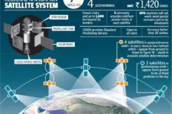
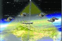
KATHMANDU: More than 8,000 pillars along the India-Nepal border will be linked to a Global Navigation Satellite System, allowing authorities for the first time to effectively manage the over 1,700-km-long porous boundary.
Nepal’s Ministry of Foreign Affairs said the Nepal-India Boundary Global Navigation Satellite System (NIB GNSS) will be used for the boundary pillars.
The decision in this regard was made at the third meeting of Nepal-India Boundary Working Group (BWG) which concluded here yesterday, a statement from the ministry said.
Krishna Raj BC, Director General of the Survey Department, led the Nepali delegation during the three-day meeting while the Indian delegation was led by Swarna Subba Rao, Surveyor General of India.
“The BWG meeting reviewed reports submitted before it by the SOC (Survey Officials’ Committee) and Joint Field Survey Teams (FST), and appreciated the progress made on the ongoing boundary work carried out at Nepal-India border,” it said.
The officials decided that the completion of the “backlogged tasks from previous field seasons” will be given high priority.
“Both the delegations reaffirmed the importance of effective boundary management. In this context, they emphasised the importance of making local authorities and people living along the border aware of the field works being conducted by joint field teams,” it said.
Before the BWG meeting, the fourth meeting of the SOC was held here from 20 to 22 June. The two countries have decided that the SOC would next meet in September this year and the BWG in August 2017, in India.
Source: PTI