ICAROS Uses TatukGIS SDK to Develop Integrated Aerial Geospatial Data Viewer
Aerial geospatial solutions provider, Icaros, Inc., selected the TatukGIS Developer Kernel (DK) to develop the next generation geospatial data viewer component of its OneButton™ software product, which is used to process raw aerial images collected from manned and unmanned aircraft into readily usable GIS compatible maps. The Icaros OneButton™ product is used by some of the largest private and government organizations worldwide operating in a range of industries.
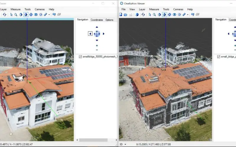
In addition to licensing the TatukGIS Developer Kernel (.NET edition) for the Icaros software development team, Icaros collaborated extensively with TatukGIS on the early development and prototyping of the DK based version of the OneButton™ Viewer application. Collaboration included customized TatukGIS development and implementation for rendering of the PLY data format for 3D photomesh objects (e.g, buildings, bridges, infrastructure, terrain, etc.) generated from aerial drone imagery, and 3D view fly-through and playback features. Additionally, TatukGIS periodically fulfilled Icaros’ requests to develop and add DK support for multi-page GeoTIFF file formats which are used for various multi-spectral applications.
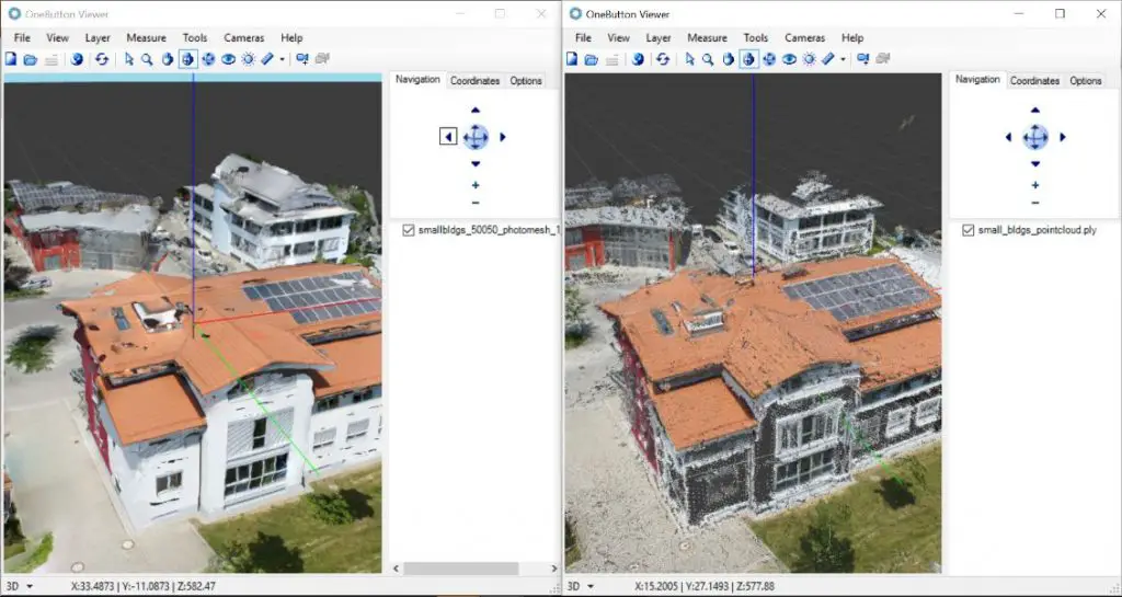
3D photomesh (left) and colored point cloud (right) shown in the TatukGIS DK based OneButton™ Viewer.
Widely recognized as the easiest-to-use processing products for remotely sensed data, Icaros OneButton™ uses advanced photogrammetric and computer vision algorithms to automatically create fully georeferenced products in 2D and 3D, while combining highly optimized performance to produce exceptionally fast and accurate results. Outputs that can be produced from OneButton™ include orthomosiacs, DEMs, true color 3D point clouds, orthorectified multispectral band mosaics, thermal images, and controlled oblique imagery. Outputs are GIS ready for use with third-party GIS and analytics software packages.
Icaros partners with Harris Geospatial Solutions as a worldwide reseller of the OneButton™ software product line. The combination of Icaros’ OneButton™ and Harris’ ENVI® provides customers with a complete and continuous workflow for processing aerial imagery into accurate georeferenced 2D & 3D maps and models, and producing application-specific analytics to solve challenging problems related to everything from agriculture and forestry to utilities and city planning.
Besides its OneButton™ product, Icaros is a comprehensive aerial geospatial solutions provider, offering photogrammetry software products, image data acquisition and processing services, analytic services and training to help companies, organizations, and government agencies make better decisions using current and accurate aerial geospatial information. Icaros’ aerial remote sensing, mapping, and GIS services provide clients with tailored solutions to support a wide range of land-use and natural resource management applications. Icaros also manufactures comprehensive mapping and surveillance solutions for the Unmanned Aerial Vehicle (UAV) industry.
Icaros customers in the private sector include organizations working in precision agriculture, forestry, energy and strip mining, real estate visualization, construction, and engineering projects. Public sector customers include national government agencies, global NGOs, and supporting companies involved in homeland security, surveillance & emergency management, aircraft flight training/simulation, and military mission planning
Learn more about Fairfax, Virginia based Icaros, Inc. and its OneButton™ line of products at: https://www.icaros.us
Learn more about TatukGIS and its GIS SDK line of products at: https://www.tatukgis.com