Global Mapper and Geographic Calculator Free Academic License Program is Now Live
![]() Hallowell, Maine – May 2, 2017 – Blue Marble Geographics (www.bluemarblegeo.com) is pleased to announce the launch of its new academic licensing program with a new web page now available with detailed information and an online application form (www.bluemarblegeo.com/academic). This pilot program allows institutes of higher education in the U.S. and Canada to deploy both Global Mapper and Geographic Calculator free of charge for classroom teaching, hands-on lab instruction, and personal student use.
Hallowell, Maine – May 2, 2017 – Blue Marble Geographics (www.bluemarblegeo.com) is pleased to announce the launch of its new academic licensing program with a new web page now available with detailed information and an online application form (www.bluemarblegeo.com/academic). This pilot program allows institutes of higher education in the U.S. and Canada to deploy both Global Mapper and Geographic Calculator free of charge for classroom teaching, hands-on lab instruction, and personal student use.
For over two decades, Blue Marble’s affordable, user-friendly GIS software has been meeting the needs of hundreds of thousands of satisfied customers throughout the world. Users come from all industries including software, oil and gas, mining, civil engineering, surveying, and technology companies, as well as government departments and academic institutions.
Since the preliminary announcement of the academic licensing program at the annual Association of American Geographers conference in Boston in early April, the response from college course administrators and faculty has been overwhelming. Unshackled from budgetary constraints and technical limitations, college instructors and lecturers can now build a hands-on curriculum that allows students to experience the practical application of spatial technology instead of countless hours of software instruction.
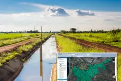
The program covers Blue Marble’s flagship software products: Global Mapper and Geographic Calculator. Ideally suited for classroom and lab use, Global Mapper is a multifunctional GIS application with particular strength in format support; raster and vector creating and editing; terrain analysis; and, using an optional add-on module, LiDAR processing. Geographic Calculator is generally regarded as the preeminent geodetic and coordinate conversion software. Built on the foundation of the largest database of geodetic definitions and coordinate system parameters commercially available, this powerful software is designed to ensure accuracy and consistency in any geospatial data management process.
“The motivation behind this program is founded on our belief that tomorrow’s graduates should have the skills and aptitude needed to meet the ever-changing needs of the GIS sector,” stated Patrick Cunningham, Blue Marble President. “We see this as a long-term investment and one that will yield positive results for institutes of higher education, for graduating students, and for the companies and organizations that will ultimately hire them.”
Blue Marble’s academic licensing program allows the use of Global Mapper and the Geographic Calculator for instructional use only. The software can be freely installed in a classroom or lab as well as on students’ personal computers. Under the academic license, the use of the software for commercial or research purposes is strictly prohibited.
For more information or to sign up for the academic licensing program, visit:
www.bluemarblegeo.com/academic
###
About Blue Marble Geographics: Blue Marble Geographics of Hallowell, Maine is a leading developer and provider of software products and services for highly accurate geospatial data conversion solutions. Blue Marble is known for their coordinate conversion and file format expertise and is the developer of the Geographic Calculator, GeoCalc SDK, Global Mapper, LiDAR Module for Global Mapper and Global Mapper SDK. The company has been writing GIS software tools and solutions for over twenty years and currently serves hundreds of thousands of users worldwide.
Contact Information:
David McKittrick
Senior Applications Specialist
Blue Marble Geographics
Hallowell, ME, USA
davidm@bluemarblegeo.com
800-616-2725
+1(207) 622-4622