Esri has announced the release of latest version 10.2.6 of the ArcGIS Runtime SDK for .NET. The allows to integrate ArcGIS functionality into Windows apps for desktop and mobile. SDK also support the integration of a wide range of mapping and GIS tasks online or offline, including editing, geocoding, routing, mapping, and data visualization.
The new release brings support for 3D mapping and Keyhole Markup Language (KML) data sources. The release also improves the quality of the APIs by addressing critical issues affecting editing, labeling, and the use of local data sources.

New functionalities @ ArcGIS Runtime SDK for .NET v 10.2.6:
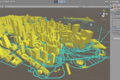
- The 10.2.6 release includes new classes to support 3D mapping ( SceneView and Scene controls).
- Support for KML version 2.2, plus some extensions. KML content can be hosted online or accessed locally and displayed in a Map or Scene. KML data can now also be consumed in your ArcGIS Runtime app (in a map or scene) using the KmlLayer class.
- Display buildings and structures using the new Scene service and display a variety of local data sources in a Scene, such as tile packages, mobile geodatabases, shapefiles, and local server services.
- Show terrain using online image services or local raster data for elevation sources.
- Extrude 2D graphics to provide 3D context.
- Use pre-defined 3D symbology and custom models to render complex 3D graphics.
- Change camera location to view Scene contents from different perspectives.
- Several new topics have been added to the Developers Guide that describe 3D mapping in ArcGIS Runtime SDK for .NET, including how to create a scene, navigate, add layers, and display 3D graphics.
Download version 10.2.6 of the ArcGIS Runtime SDK for .NET
Categories:
Software