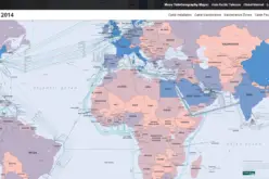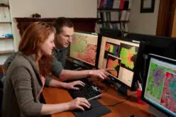
 Havana, May 7 (Prensa Latina) Cuba shows a sample called “A Look to the Outer Space”, which promotes the use of satellite remote scanning and detecting to be used for the country”s economy, and stands today in the Cuban Convention on Earth Sciences.
This is a newly developed discipline based on the remote study of the planet using sensors originally installed on board aircraft and currently in artificial earth satellites.
The president of the Cuban Society of Geology, Dr. Manuel Iturralde, told Prensa Latina at the Convention Center in Havana, the venue, that satellite technology has many applications in everyday life and social practice of Cuba.
Iturralde explained that there are many groups working on issues involving the use of satellite pictures in their research and everyday practice in Cuba, and is working on the creation of a national remote sensing center, which favors the work between those who work related to this specialty in the country.
The Cuban expert stressed the importance of the use of satellite remote sensing use in areas such as agriculture, as well as in studies of risk prevention of disasters such as floods, drought and earthquakes.
That discipline has applications also in meteorology, geology, mineral prospecting, mapping, urban planning, hydrography, oceanography, environmental monitoring, among other areas.
Nearly 1,000 professionals from 29 countries attend the 6th Cuban Earth Sciences Convention, which meets with the suggestive title of geosciences in the service of society and development.
The relationships between geology, economics and improving the quality of life are priorities of this meeting, with debates on oil and gas exploration, drilling technology reaching horizontal wells and Geophysics applied to geological exploration, among others.
The event program includes Cuban Congress on Geology, Geophysics, Computer Science and Geosciences, Mining and Oil and Gas.