
Software

Wow ! Google Earth Pro Is Now Free
Recently Google has announced that Google Earth Pro is now available for free. Google Earth Pro is geospatial software that has all the easy-to-use features and detailed imagery of Google Earth, along with

ArcGIS 10.3 Now Certified OGC Compliant
Esri Users Benefit from Interoperability Standard As part of Esri’s ongoing support of GIS interoperability, the latest ArcGIS 10.3 release is now certified as Open Geospatial Consortium, Inc. (OGC), compliant. This

Sahaaya App to Help Bengaluru Citizens in Civic Woes
In recent news, Bruhat Bangalore Mahanagara Palike (BBMP) has launched Sahaaya app, a GIS-based interface, to help citizens lodge complaints regarding civic woes. BBMP Sahaaya (Help) is a easy and user friendly
iOS Mapping Solution, SuperSurv, Enhances Raster Data Support
Supergeo releases the latest update of SuperSurv 3.2 (iOS) to enhance the functionality and efficiency for mobile GIS surveyors. Having stronger compatibility with raster dataset and convenient tools for data
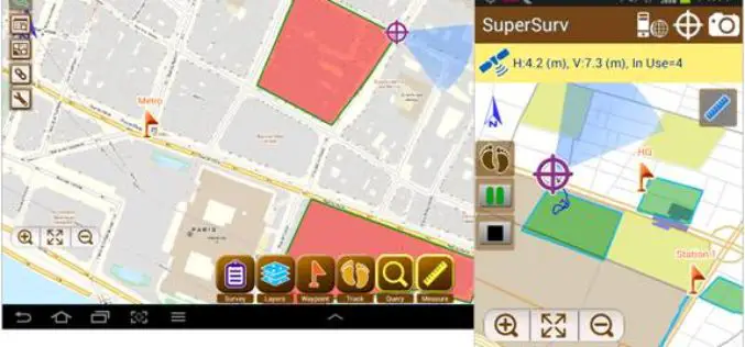
SuperSurv 3.2 Release Advanced GPS Support and Data Collection Functions
Developed by Supergeo, the latest version of SuperSurv (Android) 3.2 is upgraded with stronger data collecting function by GPS and more precise and easy-to-use GPS manipulation interface, bringing
ArcGIS Explorer is Now Available for Android
Finally the long awaiting ArcGIS Explorer on Android is now available in the Google Play Store. ArcGIS Explorer is a free GIS viewer that gives you an easy way to

GeoCue Group Announces Release of GeoCue 2014.1
Huntsville, AL – GeoCue Group Inc. is pleased to announce the release of GeoCue 2014.1. GeoCue is the world’s most powerful and popular geospatial production management software, available as a

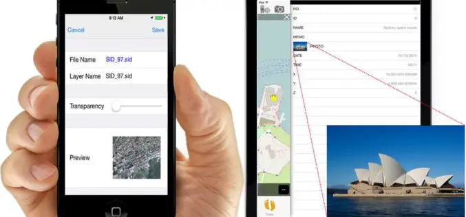
SuperSurv 3.2 Supports iOS 8 and Enhances GPS Display
SuperSurv (iOS) 3.2, the field data collecting app for iPhone and iPad users, now fully supports iOS 8 and enhances GPS display with optimal user experiences. Developed by Supergeo, SuperSurv

Avia-GIS Developed Apps to Combat Diseases Spread by Pests
In recent news by ESA, a consortium led by Avia-GIS in Belgium and supported by ESA has developed Vecmap – an all-encompassing software and services package including a smartphone app for

TerraGo Unveils Groundbreaking OpenGeoPDF Technology
OpenGeoPDF is a collection of technologies that combine open spatial database features and application logic within portable, intelligent maps. TerraGo, a leading global provider of location intelligence solutions, is pleased

