
Business

Space Flight Laboratory (SFL) Awarded Norwegian Space Agency Contract to Build NorSat-4 Maritime Tracking Microsatellite
The Norwegian Space Agency (NOSA) has awarded a contract to Space Flight Laboratory (SFL) to build the NorSat-4 maritime tracking microsatellite. NorSat-4 will be the eighth satellite developed by SFL

NAVAID Calibration Drone by Cursir Helped to Speed Up the Flight Check of the Landing System of the Ulyanovsk Airport
Last year, by order of the Federal Air Transport Agency of Russia, a working group was created on the implementation of UAVs to calibrate, check and configure navigation aids at

Pix4D Announces Entering Into An Exclusive Reseller Partnership With Beijing Skymap Technology Co., Ltd. For Mainland China
Pix4D, the photogrammetry industry leader, today announced the signing of an exclusive reseller partnership with Beijing Skymap Technology Co., Ltd. a high-tech enterprise integrating software sales, service, research and development,
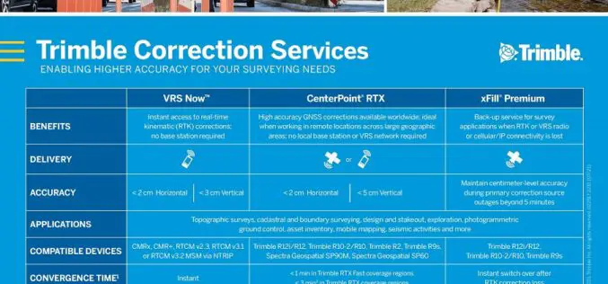
Trimble Boosts Flagship RTX Correction Services Performance – Continuing to Raise the Bar for Geospatial Users
Cutting GNSS Signal Convergence Means Significant Time Savings for Surveyors Trimble (NASDAQ: TRMB) has announced enhancements to its industry-leading Trimble RTX® correction services, tailored to meet the evolving needs of geospatial

Trimble MX50 LiDAR System Expands Mobile Mapping Portfolio
Vehicle-Mounted System Enables Data Capture for Road Agencies and Local Governments Trimble has introduced the Trimble® MX50 mobile mapping system for asset management and mapping—a new addition to its established

Euclideon Plans World’s Largest Geospatial Data Platform on Microsoft Azure, Accelerates Innovation Opportunity
Cloud based service visualises a petabyte of data per second Leading 3D data specialist Euclideon has signed a strategic partnership with Microsoft and unveiled plans to build the world’s largest geospatial data

Trimble X7 and Perspective 3D Scanning Solution Garners Three International Design Awards
Solution’s Complete and Simplified Design by Global Team is Lauded by Judges Trimble (NASDAQ: TRMB) announced today that the Trimble® X7 and Perspective 3D Scanning Solution has received three international
RMSI Partners With Enzen UK to Support Scotia Gas Network (SGN), UK for GIS Application Support and Maintenance
RMSI, a global leader in geospatial and engineering solutions, has been awarded with a GIS application support and maintenance project for Scotia Gas Network (SGN), UK’s most innovative gas distribution
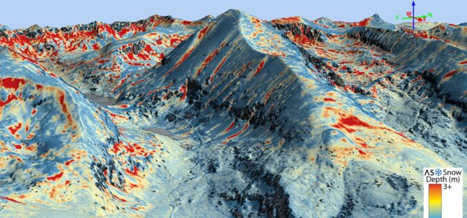
Airborne Snow Observatories, Inc. Takes Delivery of the All-New Cutting-Edge RIEGL VQ-1560 II-S LiDAR System
Airborne Snow Observatories, Inc. has just taken delivery of one of the first in North America cutting-edge RIEGL VQ-1560 II-S airborne laser scanners, just as the ASO program at NASA
SIIS and UP42 Agreement Makes KOMPSAT Satellite Imagery Available on the Marketplace
SI Imaging Services (SIIS) of Daejeon, South Korea and UP42, have signed an agreement to make imagery from the KOMPSAT satellites available on the UP42 marketplace and developer platform. The
