
GIS

Innovative Remote Sensing Applications Developed by Masdar Institute to be Implemented by Mohammed Bin Rashid Space Centre
Students and faculty from the Masdar Institute of Science and Technology have won top prizes for their innovative applications of high-resolution satellite data as part of a competition held by
Esri Updated Standard Global Demographic Data for 45 Countries
Esri has updated the Standard Global Demographic data for the 45 countries and is now available on the ArcGIS platform. The data is sourced from Michael Bauer Research, is available across the ArcGIS
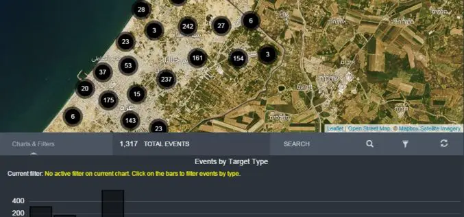
Amnesty International Launches Online Tool Mapping Exposing Israeli Attacks in Gaza
Amnesty International and Forensic Architecture has launched an investigative online tool mapping Israeli attacks in Gaza during the conflict of July and August 2014. The mapping tools aimed to push accountability
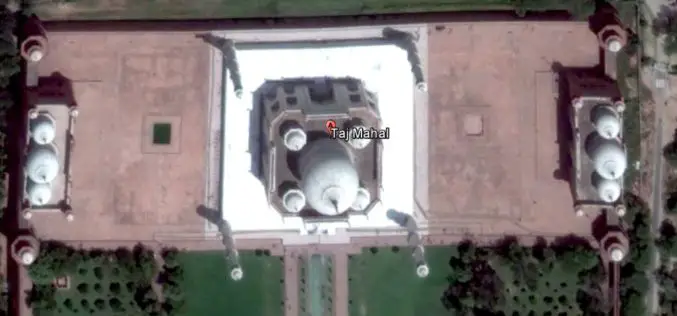
India May Soon Have 3D Imagery of Major Cities
3D imagery of buildings and terrain of India’s major cities, including Rashtrapati Bhavan and PMO, could soon be seen in Google Earth with the government contemplating to give permission for
UNESCO and UNITAR-UNOSAT Signed an Agreement to Protect Heritage Using Geospatial Technologies
UNESCO and UNITAR (the UN Institute for Training and Research) have signed an agreement to protect cultural and natural heritage sites with the latest geospatial technologies. It was signed at
4Dmapper to Store, Deliver and to Share Geospatial Data
4Dmapper is a web based geospatial product. If you are thinking that it is same as Google Earth or Bhuvan; NO, 4Dmapper is a rich, purely browser based 3D environment

OGC requests comment on extension that integrates OGC WCS Standard with JPEG 2000 and JPIP
Members of the Open Geospatial Consortium (OGC®) request comments on the OGC® Web Coverage Service 2.0 Interface Standard – JPEG2000/JPIP Coverage Encoding Extension – abbreviated as “JPEG2000/JPIP-Coverage”. This candidate OGC
ISPRS Releases The International Archives of the Photogrammetry, Remote Sensing and Spatial Information Sciences
The International Archives of the Photogrammetry, Remote Sensing and Spatial Information Sciences is the series of proceedings published by the International Society of Photogrammetry and Remote Sensing (ISPRS). The Archives
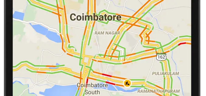
12 Cities in India to Get Live Traffic Updates Through Google Map
Never miss your flight or train, use Google Map to get real time traffic updates to route your drive around the traffic and save your time. Google has launched the

Google Maps Will Soon Alert Drivers about Railroad Crossings
According to The New York Times, the Federal Railroad Administration, United States of America and Google have agreed to update its maps with crossing locations. The new maps will ensure
