
GIS
Drones to Conduct Aerial Surveys of Mines for Coal India
KOLKATA: Coal India is planning to start using drones to conduct aerial surveys of mine blocks that come up for exploration and to assess the extent of greenery restored after

President’s 2017 Budget Proposes $1.2 Billion for the USGS
Reflects the ongoing commitment to scientific discovery and innovation to support decision making for critical societal needs WASHINGTON—The President’s fiscal year (FY) 2017 budget request for the U.S. Geological Survey
NHAI and WII to Develop GIS Maps of National Highways Passing Through Protected Areas
IANS | New Delhi – The National Highways Authority of India (NHAI) on Monday said it created a dialogue platform with stakeholders to mainstream sustainable development and environmental management in

FOSS4G NA 2016: Open Source Photogrammetry with OpenDroneMap
OpenDroneMap (ODM) aims to be a full photogrammetric solution for small Unmanned Aircraft (drones), balloons, and kites. ODM acts as a tool for processing highly overlapping unreferenced imagery, turning the
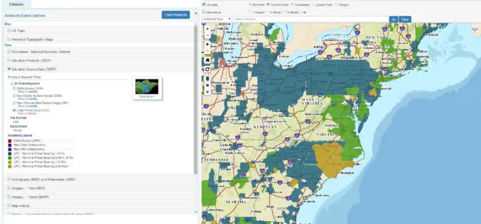
The National Map Data Download Enhancements
The USGS National Map program is transitioning all of its GIS data download capabilities to its new TNM Download client during the week of February 15, 2016. The new launch

Online Portal Improves Access to Geoscience Data From Africa
The Botswana Geoscience Institute (BGI) is launching a Geoscience Portal that provides free access to multi-disciplinary datasets from Ngamiland, a district in the country’s northwest, for a period of one year.
Indian Meteorological Department Deploys a Web GIS Solution to Deliver Real-time Weather Forecast
According to recent news by The Times of India, the Indian Meteorological Department (IMD) has deployed a web GIS solution in order to deliver real-time highway weather forecast updates. The Highway

USGS Increases Public Access to Scientific Research
The U.S. Geological Survey is implementing new measures that will improve public access to USGS-funded science as detailed in its new public access plan. The plan enables the USGS to
Delhi Police to Use Space Tech for Crime Control
The Delhi Police will soon start using space technology for live crime mapping and adopting a “predictive policing” mechanism being developed in partnership with the Indian Space Research Organisation. “The

Mumbai Metropolitan Region Tied Up With the World Bank
Mumbai, India – According to recent news by The Indian Express, Mumbai city development authority has tied up with the World Bank to map the entire Mumbai Metropolitan Region (MMR),
