
GIS

exactEarth Release Tracking Data of the Search for MH370
Malaysia Airlines Flight MH370, which disappeared over two weeks ago en route to Beijing, appears to have crashed thousands of miles away in the southern Indian Ocean, exactEarth have released the

NOAA and NASA Launch Coastal Vulnerability Innovation Challenge
Coastal communities are becoming increasingly vulnerable to the risk of damage from coastal inundation. We only have to remember the recent impact of Hurricane Sandy on communities in the northeast

SuperGIS Server Builds Decision Supporting GIS for National Development
Supergeo Technologies, a leading global provider of GIS software and solutions, supports Taiwan National Development Council to integrate various geographic data and services collected by different divisions into one single

TERI Develops Web GIS Tool Trap Rooftop Solar Power
The Energy and Resources Institute (TERI) has developed the first-ever open-source Web-GIS Tool for estimating rooftop solar power potential for Indian solar cities. The tool aims to develop a high

GIS to Add Traffic Intelligence in Abu Dhabi
In recent news, Abu Dhabi is using a unique intelligence system “Intelligent Safety Management System” which uses Geographical Information System to create solutions for certain problems such as speeding and

Mystery Deepens As Search Area Expands For Malaysia Airlines Flight MH370
It has been 12 days to the missing Malaysia Airlines flight MH370 since March 8. The search for Flight MH370 has now been expanded deep into the northern and southern hemispheres.

Cadastre 2034 – New Zealand’s New Cadastral Strategy
The Cadastre 2034 is a designed to ensure that in the future New Zealanders will be able to more easily understand where their rights in land actually are, and will

OGC Announces New Discrete Global Grid Systems Standards Working Group
The Open Geospatial Consortium (OGC®) announces the formation of a new OGC Technical Committee Standards Working Group (SWG). The purpose of this SWG will be to explore and propose terms
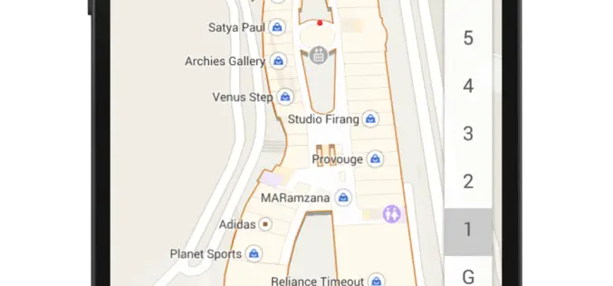
Indoor Google Maps for 75 Popular Indoor Venues
In a recent post in Google India blog, Indoor Google Maps comes up with 75 popular indoor venues across 22 cities in India. Google India has adopted My Location technology to
Qatar University Begins Digital Archiving
In a recent news by Gulf Times, Remote Sensing and Geographic Information Systems (GIS) Unit in the Environmental Studies Centre (ESC) at Qatar University has initiated the course of action to digitally
