
E-books

Non-Programmer’s Tutorial for Python 2.6
The Non-Programmer’s Tutorial For Python is a tutorial designed to be an introduction to the Phyton programming language. This guide is for someone with no programming experience.

Spatial Decision Support Systems Principles and Practices
Spatial Decision Support Systems Principles and Practices Ramanathan Sugumaran John DeGroote Spatial decision support systems (SDSS) are designed to help decision makers solve complex spatially related problems and provide a

PR: New Esri Book Inspired by Classic Flow Map of Napoleon’s Russian Campaign
Mapping Time Examines Challenges of Temporal Mapping Redlands, California—Published by Esri Press, Menno-Jan Kraak’s book Mapping Time: Illustrated by Minard’s Map of Napoleon’s Russian Campaign of 1812 combines historical and geographic analysis with
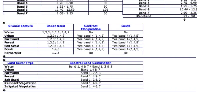
Band Combination of Landsat Thematic Mapper
The PDF will give detail information about band combination information in detail for Landsat Thematic Mapper Satellite. Download Band Combination

Emergency Mapping Guidelines
The aim of the guidelines is to help support an effective exchange and harmonization of emergency mapping efforts leading to improved possibilities for cooperation amongst involved Emergency Mapping Organizations. This

Information Boucher on Global Precipitation Measurement (GPM) Core Observatory
The Global Precipitation Measurement (GPM) mission is an international partnership co-led by NASA and the Japan Aerospace Exploration Agency (JAXA). The mission centers on the deployment of the GPM Core

Digital Orthoimagery Base Specification V1.0
Abstract The resolution requirement for orthoimagery in support of the The National Map of the U.S. Geological Survey (USGS) is 1 meter. However, as the Office of Management and Budget
Solving Optimization Problems using the Matlab Optimization Toolbox – a Tutorial
Solving Optimization Problems using the Matlab Optimization Toolbox – a Tutorial TU-Ilmenau, Fakultät für Mathematik und Naturwissenschaften Dr. Abebe Geletu Download Solving Optimization Problems using the Matlab Optimization Toolbox – a Tutorial
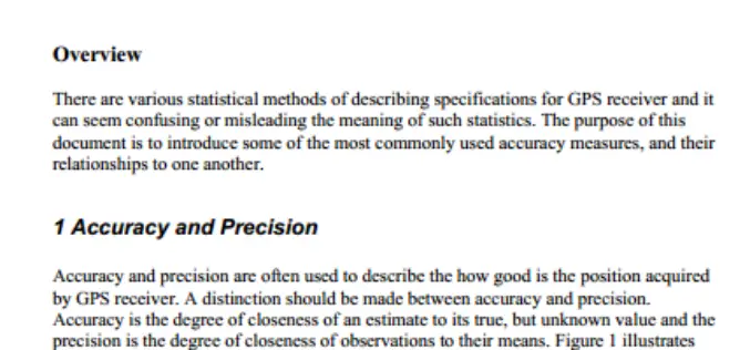
GPS Position Accuracy Measures By NovAtel
GPS Position Accuracy Measures Overview There are various statistical methods of describing specifications for GPS receiver and it can seem confusing or misleading the meaning of such statistics. The purpose

PPT-Aerial Imagery By David Davis, USDA Farm Service Agency, Aerial Photography Field Office
This PPt gives an historical and present overview of how Aerial Photogrammery has changed. Written by: David Davis, USDA Farm Service Agency, Aerial Photography Field Office Download PPT-Aerial Imagery By David Davis
