Laser maps collected by airborne mounted sensors have, for the first time, been used to successfully segment individual trees affected by the deadly Larch tree disease. The laser scanning surveys (LiDAR) were undertaken by aerial mapping company Bluesky and used to model tree canopy height models as part of a wider study to prove the effective use of the technology for disease identification and monitoring.
Phytophthora ramorum is a fungus-like pathogen which causes extensive damage and mortality to a wide range of trees and other plants. Generically referred to as ramorum, the disease was first discovered in the UK back in 2002 and has now spread to sites from Cornwall to Scotland, causing destruction in high profile areas including Epping Forest and the Forest of Dean.
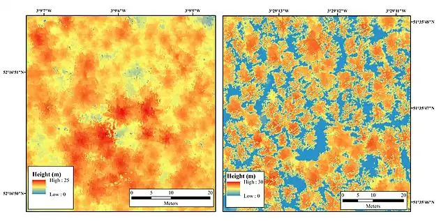
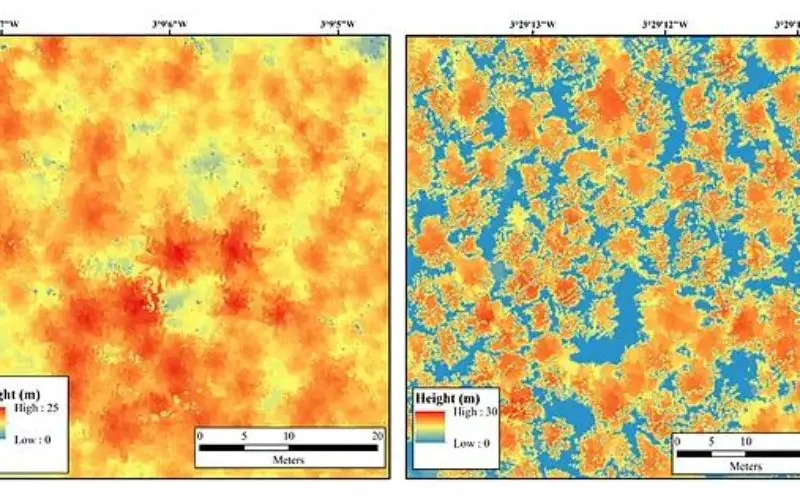
Non infected trees shown on the left and infected trees shown on the right.
“Current trends suggest that UK forests and woodlands are subject to a greater threat from exotic diseases, such as Larch tree disease, than ever before,” commented Chloe Barnes, Postgraduate Researcher at the University of Leicester and author of the study. “While the use of LiDAR in forestry applications has become more common, its use to identify individual trees affected by diseases has, until now, been underutilised.”
LiDAR has been used extensively to derive canopy height models (CHMs); in fact it is one of the key datasets used to create Bluesky’s unique National Tree Map. However, when trees are affected by disease, evidenced by defoliation and dieback, irregularities across the entire canopy add complications to the segmentation of individual tree crowns (ITCs).
Using the Bluesky LiDAR data, sample plots of two study sites in Wales were assessed using different segmentation algorithms. A series of raster format CHMs were computed at different pixel sizes and tested across a range of plantation larch plots in order to perform ITC delineation.
“The three dimensional nature of LiDAR provides structural information on topography, canopy height, tree density and crown dimensions, which we have proved can be used to determine biophysical parameters and inform forest inventories,” concluded Barnes. “The high resolution and accuracy of the data also enables the extraction of forest parameters associated with individual tree crowns, including the opportunity for the detailed study of forest condition and dynamics.”