
Posts From GIS Resources
Transerve Has Been Granted a Patent for Their Online Spatial Analytics Platform’s Micro-Service-Based Design
Transerve, a location intelligence firm that allows digital transformation and effective decision making, has received a patent for its invention named “System and method for revenue and asset management based

Effective Guidelines to Become a Professional Trader
When a trader learns about Forex trading, he cannot wait to participate in this industry. Every individual tries to make a career out of currency trading here. Most individuals also

Trimble Establishes Dr. Gladys West Scholarship Program
Scholarship Program to Honor Technology Pioneer and Hidden Figure Who Helped Invent GPS Trimble announced today a scholarship program to honor Dr. Gladys West, a pioneer in mathematics, minority advancement and the
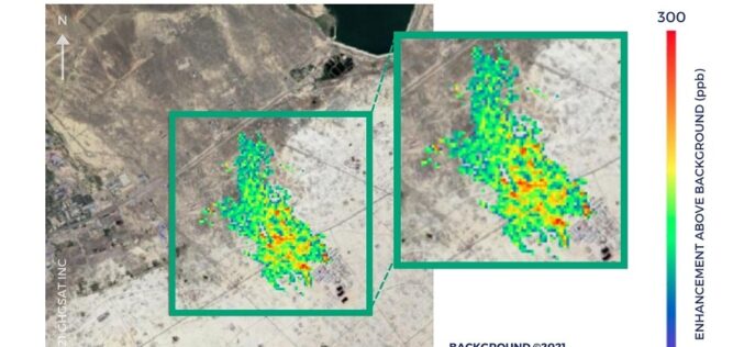
Partnership Announced by SI Imaging Services with GHGSat for Methane Emissions Monitoring
SI Imaging Services (SIIS) has embarked on a collaborative partnership with GHGSat, a Canadian satellite company specializing in greenhouse gas monitoring from space. Effective June 16th, 2021, SI Imaging Services

Pix4D Launches in the USA and Canada, the viDoc RTK rover, an iPhone Case that Enables Handheld Professional 3D Scanning
Pix4D, the market leader in photogrammetry solutions, has just made the viDoc RTK rover available for purchase in the USA and Canada. Already available in Europe, the German-designed rover attaches

Trimble and Microsoft Partner to Drive Digital Transformation Across Industries
Initial Focus—Companies to Develop an Industry Cloud to Enable Construction Organizations to Harness the Value of Digital Construction Data Across the Project Lifecycle from Design, Build and Operate Trimble (NASDAQ:
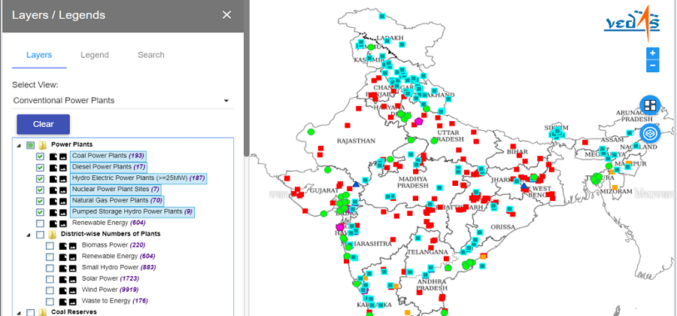
Geospatial Energy Map of India for Effective Planning of Resources
NITI Aayog in collaboration with the Indian Space Research Organisation (ISRO) has developed a comprehensive Geographic Information System (GIS) Energy Map of India with the support of Energy Ministries of Government

RedTail Delivers LiDAR System to DoD’s Explosive Ordnance Disposal Community
RedTail LiDAR Systems, a leader in microelectromechanical systems (MEMS) mirror-based light detection and ranging (LiDAR) technology, has delivered six LiDAR systems to the 707th Ordnance Company stationed at Joint Base Lewis-McChord. These

India Signed Arrangement on the Joint development of a Small Satellite for Bhutan
India signed the implementing arrangement on the joint development of a small satellite for Bhutan. The agreement was inked by Shri R Umamaheswaran, Scientific Secretary, Indian Space Research Organisation, and

25 years of successful cooperation between GAF AG (Germany), DLR (Germany) and Antrix (India)
GAF, the German Aerospace Center (DLR) in Neustrelitz and Antrix Corporation have a successful cooperation stretching back 25 years. In 1996, they signed agreements for the purpose of receiving Indian Earth observation
