Col-East Inventories Salt Piles from the Air Each Winter in Preparation for Snowy Weather
NORTH ADAMS, Massachusetts, 20 March 2018 – Surveying and Mapping Consultants Inc. (SMC) of Braintree, Mass., has teamed with Col-East International Ltd. for the past 12 years to monitor inventories of salt that will be applied to snowy Northeast roadways every winter. Col-East captures the inventory data safely and accurately using high-resolution aerial imagery.
“Thousands of tons of salt are used to melt the snow and make road conditions safer for drivers every year,” said Col-East General Manager Mark Thaisz. “The salt has to be accounted for just like any other asset, and aerial imagery is a cost-effective way to do it.”
A New England accounting firm hired SMC to calculate volumetric inventories on behalf of a private company that imports the salts to U.S. ports and then sells it to local governments. Due to the tax implications, the accountants needed an accurate measurement of the portside salt piles near the end of each year.
“Surveying those salt piles manually is impractical because it’s time consuming and dangerous due to the height and steepness of the slopes,” said Kevin Hanley, PLS, President of SMC. “We knew aerial imaging would be the most effective method of performing the surveys.”
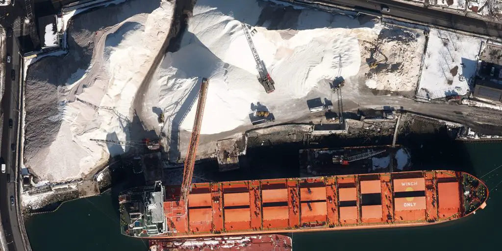
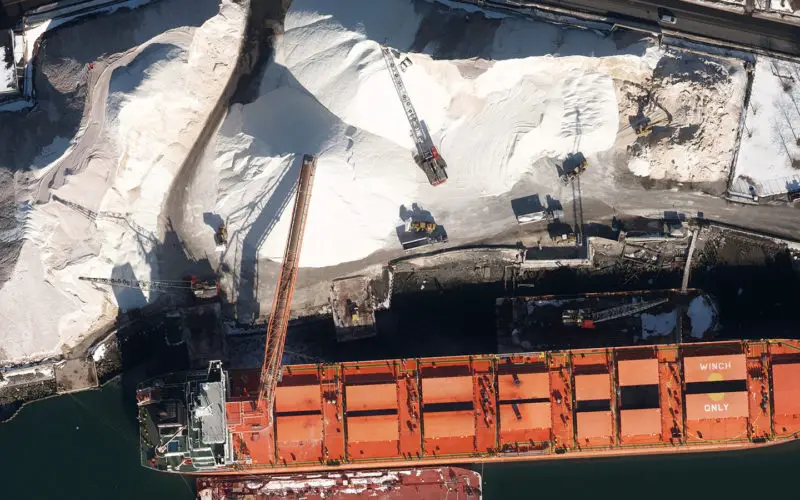
Aerial image of salt being unloaded from ship at the Chelsea Docks in New York Harbor.
SMC turned to Col-East, a provider of aerial photogrammetric services in the Northeast U.S. since 1952 and an SMC partner on several previous infrastructure planning projects. For the past 12 years, Col-East has dispatched an aircraft during the last week of December to capture aerial images of salt piles in multiple ports from Maine to Maryland. From the imagery, Col-East photogrammetrists determine the area and height of each pile to calculate its total volume.
“For the past two winters, we’ve collected digital imagery with our new Vexcel UltraCam Eagle airborne sensor, which enables us to capture data faster and more accurately,” said Thaisz. “The UltraCam lets us operate with less ground control, yet it captures extremely sharp imagery at 5-centimeter spatial resolution.”
SMC confirmed the airborne digital sensor produces imagery with striking sharpness and visual detail. Upon receiving the volumetric calculations from Col-East, SMC runs the data through an engineering software package to verify the results before delivery to the accounting firm.
“In addition to salt pile monitoring, aerial imagery has numerous applications for quickly and accurately making volumetric calculations, especially in cut-and-fill operations related to construction and engineering projects,” said SMC’s Hanley. “We’ve relied on Col-East image data on numerous transportation and utility corridor survey projects here in New England.”
SMC and Col-East have teamed on several recent infrastructure development projects in New England, including:
- Harwich, Mass., municipal sewer system design on Cape Cod,
- Cape Cod Rail Trail extension to the Brewster beaches on Cape Cod,
- Rutherford Avenue corridor improvements, Boston, for which SMC collected mobile LiDAR of the corridor and merged it with high-resolution aerial imagery from Col-East.
“We team with Col-East on these projects because they are extremely responsive, and the quality of their work is terrific,” said Hanley.
About Col-East International Ltd. (www.col-east.com)
Based in North Adams, Mass., Col-East has been providing quality aerial photography and photogrammetric services to clients in the Northeast United States from Maine to New Jersey since 1952. Col-East derives orthoimagery, 3D terrain models, topographic maps and 3D building models from the airborne imagery and LiDAR it collects and delivers end products in a variety of GIS and CAD formats.
In early 2017, Col-East was acquired by Bluesky International, an aerial mapping innovator based in the United Kingdom. Bluesky specializes in acquiring aerial photography, LiDAR and thermal data using the very latest survey technology. Bluesky is leading the way in developing innovative solutions for environmental applications, including the UK’s first National Tree Map (NTM), solar mapping and citywide ‘heat loss’ maps and is currently developing noise and air quality mapping products. www.bluesky-world.com
Contacts
Mark Thaisz
Email: mthaisz@col-east.com
Direct Tel: 800-359-8676 x208
Col-East, Inc.
P.O. Box 347
Harriman & West Airport
North Adams, Massachusetts 01247
800-FLY-TOPO (359-8676)
www.bluesky-world.com
www.col-east.com