A Benchmark of Lidar-Based Single Tree Detection Methods Using Heterogeneous Forest Data from the Alpine Space
A Benchmark of Lidar-Based Single Tree Detection Methods Using Heterogeneous Forest Data from the Alpine Space
– Lothar Eysn, Markus Hollaus, Eva Lindberg, Frédéric Berger, Jean-Matthieu Monnet, Michele Dalponte, Milan Kobal, Marco Pellegrini, Emanuele Lingua, Domen Mongus and Norbert Pfeifer
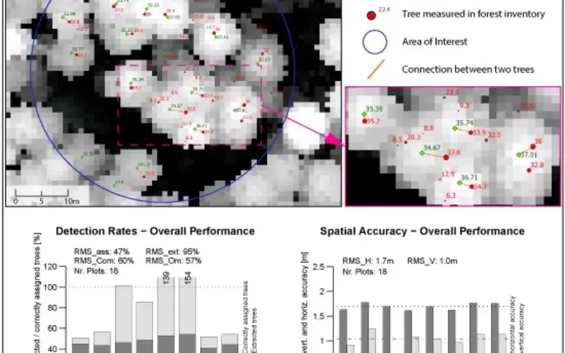
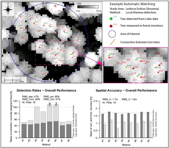 Abstract: In this study, eight airborne laser scanning (ALS)-based single tree detection methods are benchmarked and investigated. The methods were applied to a unique dataset originating from different regions of the Alpine Space covering different study areas, forest types, and structures. This is the first benchmark ever performed for different forests within the Alps. The evaluation of the detection results was carried out in a reproducible way by automatically matching them to precise in situ forest inventory data using a restricted nearest neighbor detection approach. Quantitative statistical parameters such as percentages of correctly matched trees and omission and commission errors are presented. The proposed automated matching procedure presented herein shows an overall accuracy of 97%. Method based analysis, investigations per forest type, and an overall benchmark performance are presented. The best matching rate was obtained for single-layered coniferous forests. Dominated trees were challenging for all methods. The overall performance shows a matching rate of 47%, which is comparable to results of other benchmarks performed in the past. The study provides new insight regarding the potential and limits of tree detection with ALS and underlines some key aspects regarding the choice of method when performing single tree detection for the various forest types encountered in alpine regions.
Keywords: single tree extraction; airborne laser scanning; forest inventory; comparative testing; co-registration; mountain forests;Alpine Space; matching