25 Years Ago – Europe’s First Earth Observation Satellite Was Launched
• First European radar satellite ERS-1 revolutionised satellite Earth observation by revealing never before seen details
• ERS satellite programme laid the foundations for modern radar satellite technology and applications
On the large screen of the European satellite control centre in Darmstadt, hundreds of aerospace experts, scientists, representatives from industry and journalists watch the countdown for Ariane flight number 44 with bated breath. It is Wednesday, 17 July 1991.
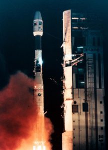
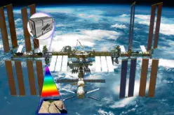
Launch of ERS-1 Earth observation satellite
As the launcher carrying the ERS-1 Earth observation satellite of the European Space Agency thunders into the night sky in the early hours (03:46 CEST) over the spaceport near Kourou (French Guiana), none of those present could know then that they were watching the launch of what would become the prototype of all modern European Earth observation satellites. The ERS-1 mission marked not only the advent of modern Earth observation by ESA but also the beginning of a long and long-lasting success story of remote observation by Space Systems of Airbus Defence and Space.
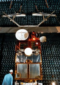
Weighing around 2.4 tonnes, ERS-1 was developed and built by an industrial consortium of more than 50 companies in 14 countries led by what is today Airbus Defence and Space. It was the most modern and complex satellite of its time and was the first European satellite to be equipped with a radar system and microwave instrumentation for taking measurements and acquiring images over land and sea. This made it possible for the first time to observe regions of the Earth that had often remained hidden under clouds or fog.
At the heart of the ERS-1, which operated in a polar orbit 785 kilometres above the Earth, was a radar with a 5.7-centimetre
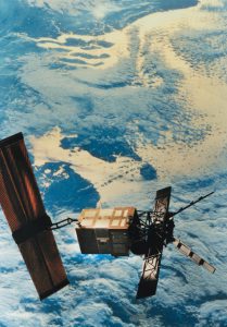
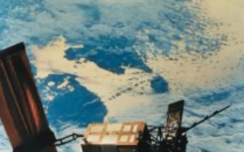
ERS-1 satellite in orbit
wavelength (corresponding to a frequency of 5.3 GHz in the C band). Every time the satellite orbited the Earth, its beam scanned a 4,000-kilometre long and 100-kilometre wide strip of the Earth’s surface. This enabled images with a resolution of 30 metres to be generated.
Originally, ERS-1 was designed to have a service life of three years, but it ended up operating for three times as long. By the time it had reached the end of its service in 2000, it had orbited the planet 45,000 times and transmitted 1.5 million images to Earth. The satellite was finally taken out of service in March 2001. ERS-1 was the pioneer of environmental research from space.
Its areas of application were just as diverse as its user communities. Three of the headlines from the 1990s demonstrate this: Following on the trail of El Niño – ERS-1 measures the temperature of the ocean current. Satellite catches polluters red-handed – ERS-1 discovers ships discharging oil into the sea. Looking through the ice with radar eyes – ERS-1 explores the ocean floor relief under the Arctic ice cap.It could also measure the direction and speed of the wind over the oceans. Meteorological organisations across the world have only had this data for forecasts since ERS-1 in 1991.
 When ERS-2 lifted off four years later (April 1995), many more uses opened up. First, this satellite was also equipped with GOME (Global Ozone Monitoring Experiment), which monitored the ozone content of the stratosphere and, in particular, the changes to the ozone hole over the South Pole.
Second, both radar satellites were operated in parallel for a few years. During this tandem mission of ERS-1 and 2, the new radar technique of interferometry was tested. Two or more images of the same area taken by the two satellites at different times are used for this. Superimposing the images gives what is known as an interferogram. It can be used to generate digital terrain models with elevation at a resolution of a few metres. Moreover, it is possible to register changes that have occurred between images taken of the surface with millimetre accuracy.
Based on the ERS experience, a series of national satellite programmes and further European projects were initiated. Under the leadership of Airbus Defence and Space, the environmental satellite Envisat (2002-2012) and Europe’s first polar orbiting meteorological satellite MetOp (since 2006) were developed. From 2021, the second-generation MetOp satellites (MetOp-SG) will take over observation. Satellites with a predominately scientific mission are called Earth Explorers. Airbus Defence and Space is responsible for the ice research satellite CryoSat (launched in 2010) and the three-satellite Swarm mission (launched in 2013) that studies the magnetic field of the Earth. Aeolus, EarthCARE and Biomass are three further Earth Explorers being developed for ESA. Airbus Defence and Space has primed more than 40 Earth observation programmes which have together clocked up more than 300 successful years in orbit.
Sentinel-1A was launched in April 2014 as the first satellite for the European Copernicus Programme (EC/ESA) for environment and security. Copernicus was developed to deliver important information in six key areas: land management, the marine environment, atmosphere, emergency response, security and climate change. The comprehensive and uniform data necessary for environmental monitoring on a global scale is inconceivable without satellite systems. Copernicus satellite-supported Earth observation is of outstanding importance due to the creation of independent access to global Earth observation data.
The Sentinels, developed especially for Copernicus are at the core of the space component. Airbus Defence and Space is leading the industrial management of five of the seven Sentinel satellite missions. The Copernicus satellites Sentinel-5P and Sentinel-2B are undergoing final testing and preparation for their launch.
With more than 50 years of experience in Space, Airbus Defence and Space has unique expertise and comprehensive know-how in the design, manufacture, test and operation of satellites, instruments and components, and the associated services, that have made it the second largest space company in the world and given it a leading position in the export of satellites.
About Airbus Defence and Space
Airbus Defence and Space, a division of Airbus Group, is Europe’s number one defence and space enterprise and the second largest space business worldwide. Its activities include space, military aircraft and related systems and services. It employs more than 38,000 people and in 2015 generated revenues of over 13 billion Euros.